The condition and quality of transport infrastructure is critical to the economic and social wellbeing of Northern Ireland (NI). There can be huge costs where transport infrastructure fails or is damaged in some way with delays to travel. If transport infrastructure is particularly old or is poorly maintained, it is more vulnerable to damage. The damage is highly likely to be caused by weather-induced events: coastal and river flooding, extreme temperatures, high winds, and landslides. The magnitude and recurrence of these events are increasing due to climate change.
Climate risk to transport infrastructure in NI are discussed in this blog article, in addition to adaptation measures. This article summarises a recently published research paper.
Transport infrastructure in NI
In NI, the public road network is just over 25,000 km and was estimated to have a net worth of £32 billion in 2016. There are five railway lines making up around 350 km of rail network in NI. There are four main modes of public transport: Ulsterbus, Metro, Glider and Train. The public transport network covers 43 million miles per annum and provides 83% of the NI population direct access to public transport.
The Department for Infrastructure (DfI) is the sole road authority in NI and is responsible for its maintenance and upkeep. The DfI also controls and regulates all public transport in NI. Services are operated by three private limited subsidiary companies, Ulsterbus, Metro and Northern Ireland Railways (NIR), trading jointly as Translink.
Spending of transport infrastructure in NI
NI spends the least amount on public transport (£84 per person) compared to England, Scotland, and Wales. Translink stated that this figure decreased from £97 in 2013.
Figure 1 shows a breakdown of public expenditure on NI roads. It shows that total spending on roads has only incrementally increased over the last few years. There has also been a decline in the expenditure in maintenance of structures and bridges, in addition to routine maintenance.
The Institution of Civil Engineers (ICE) released a report in 2020 which stated that there are several issues with infrastructure provision in NI. In this same year, the Infrastructure Minister said that years of underinvestment has led to a deterioration of NI’s roads. In July 2021, the Minister bid £120 million for road maintenance in this financial year. However, the Barton report (a review of structural maintenance funding for DfI roads) identified an investment requirement of around £140 million per annum to maintain the road network. A report by the NI Audit Office estimated that the current cost to clear the road maintenance backlog is £1.2 billion.
Climate change in NI
The International Panel on Climate Change (IPCC) stated that human-induced warming reached approximately 1⁰C above pre-industrial levels in 2017 and is following a warming trend, the future projection of which depends on the emissions pathway that is taken.
This warming is already affecting climate systems. The UK Climate Projections 2018 (UKCP18) report outlines that the decade 2009-2018 has been on average 1% wetter than 1981-2010 and 5% wetter than 1961-1990 for the UK overall. Total rainfall from extremely wet days increased by about 17% in the decade 2008-2017 for the UK overall. In NI, the annual mean rainfall has increased 6.4% from 2010 to 2019.
Representative Concentration Pathways (RCP) are scenarios of concentrations of GHG emissions that result in differing levels of global warming by 2100, relative to pre-industrial levels:
- RCP2.6: emissions are highly reduced, resulting in global warming of 1.6⁰C by 2100.
- RCP8.5: GHGs continue to be emitted unmitigated and global warming reaches 4.3⁰C by 2100.
- RCP4.5 and RCP6.0: two medium stabilisation pathways, that result in warming of 2.4⁰C and 2.8⁰C by 2100, respectively.
Table 1 displays NI climate predictions compared to a 1981-2000 baseline average for 2050 and 2080 based on different RCP pathways.
| RCP2.6 | RCP6.0 | RCP8.5 | ||||
| 2050 | 2080 | 2050 | 2080 | 2050 | 2080 | |
| Summer rainfall (%) | -11 | -10 | -11 | -15 | – | – |
| Winter rainfall (%) | +3 | +7 | +3 | +10 | – | – |
| Annual temperatures (⁰C ) | +1.1 | +1.2 | +1.2 | +2.1 | – | – |
| Sea level (cm) | +14 | +27 | – | – | +16 | +58 |
Because of this warming, climate risks to transport infrastructure are changing. These include high temperatures, increased extreme rainfall events and flooding, sea level rise causing increased coastal flooding and erosion, and increased likelihood of landslides. Each of these risks will now be discussed, in addition to adaptation measures that improve resilience to them.
High temperatures
Increasing global temperatures are causing an increase in the number and intensity of heat waves in the UK, as well as drier summers. High temperatures can cause damage to pavements, roads, bridges, and rail tracks. In July 2021, NI recorded its highest-ever temperature which caused a speed restriction on trains due to high track temperatures and caused bitumen in some roads to soften. Roads soften when temperatures regularly reach 20⁰C, as the dark asphalt road surface absorbs a lot of heat. When bitumen softens, it can rise to the top making the road more susceptible to ridging and rutting.
In a response to the softening of roads due to heat in the south of the UK, the highway authorities spread granite dust to absorb soft bitumen to stabilise the surface. Polymers can also be used to raise the softening point of asphalt road surface to about 80⁰, preventing tarmac from softening in hot weather.
Network Rail, the company which owns and operates rail infrastructure in Great Britain, has a New Measurement Train that helps to locate and identify faults before they become an issue.
Although there are reactive measures to reduce the impact of heat on transport infrastructure, there is no current strategy in NI for inspecting bridges or rail track for buckling due to heat.
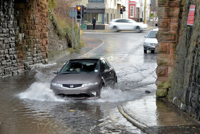
Heavy rainfall and flooding
Heavy rainfall events and flooding are becoming more common in NI. Flooding can damage the structural integrity of roads, railway tracks and bridges. During an evening in August 2017, the north-west of NI experienced 60-70 mm of rain (63% of the average rainfall for August) in the space of 8-9 hours resulting in widespread flooding. 210 roads were closed or impacted, and 89 bridges required remedial action, including the collapse of the Glenrandal Bridge in Claudy.
Data from the DfI shows that there were 9,961 reports of flooding along roads from 1st August 2017 to the 19th of October 2021. Figure 2 displays the number of reports of flooding along roads from 1st January 2018 to 31st December 2020 alongside monthly average rainfall for NI (1981-2010).
Rainfall is seen as one of the major causes of deterioration to roads in creating and widening cracks and initiating potholes. As the rate and intensity of rainfall events increases, the rate of deterioration will also increase, albeit with some uncertainty. Given that the current condition of roads in NI is poor, especially rural roads, the problem will be exacerbated by rainfall.
A study that modelled bridges in the UK found that increased winter precipitation and river flows will increase scour at bridges, potentially increasing the rate of failure to an average of one bridge per year in the UK. Scour is the erosion of material from the bed/banks of a stream around a bridge due to the water flow itself. This compromises the structural integrity of the bridge.
The Third UK Climate Change Risk Assessment (CCRA) for NI found that currently 183 km of railway lines are at a 1:30 risk of surface water flooding and that 87 km of railway lines at a 1:75 risk to river flooding. The risk of river flooding to railway lines is estimated to increase by 50% by the 2080s in a +4⁰C by 2100 scenario. Under the same scenario, the risk of railway lines flooding by surface water increases by 137%.
There are many flood management strategies for NI:
- The DfI has overall responsibility for flood risk management and policy in Northern Ireland. DfI Rivers carries out a rolling programme of planned inspection of watercourses to identify where maintenance work is required.
- Flood hazard maps have been produced in accordance with the EU Floods Directive to indicate areas that have been determined by the government to be at significant risk of flooding.
- The Flood Risk Management Plan (FRMP) 2021-2027 was published for public consultation in December 2020. This takes the NIFRA 2018 assessment into account, in addition to a methodology on the calculation of damages.
- Sustainable Water – A Long-Term Water Strategy for Northern Ireland (2015- 2040) outlines a Flood Risk Management Strategy.
- NI Water published ‘Our Strategy 2021-2046’ in 2021 which recognises the climate emergency as one of six strategic risks for the next 25 years.
- The NI Climate Change Adaption Programme (NICCAP2) was published in 2019. One of the key actions in this was to increase the number of sustainable drainage systems (SuDs) introduced in new developments. SuDs reduce the risk of surface water flooding by slowing down the flow of run off through the use of permeable surfaces, storage tanks and ponds.
Although there are multiple flood management documents for NI, none include consistent indicators of resilience to flood risk across transport infrastructure.
The general deterioration of roads in NI, especially rural roads, due to lack of funding over the years could be exacerbated with predicted future heavy rain events.
Sea level rise
Global sea level rise increases the risk of coastal flooding and erosion which endangers transport infrastructure on the coast. Coastal flood risk increases disproportionately for an equivalent global warming level compared to flood risk from other sources (such as river and surface water flooding). A coastal screening tool shows that rising sea levels could flood the coastline of Belfast by 2050. This tool also shows rising sea levels could flood much of Newtownards, the Ards Peninsula and low-lying farmland around the coast of Lough Foyle in Co Derry/Londonderry.
The third CCRA for NI estimated that 20 km of railway lines and three railway stations in NI are at 1:75 chance or greater risk of coastal flooding. They also predict that in the absence of further adaptation and in a +4°C at 2100 scenario, by 2080 the length of railway track exposed to coastal flooding could potentially double in Northern Ireland (100% increase).
No single Executive Department has the responsibility for coastal erosion risk management. The third CCRA for NI stated that:
…the available evidence indicates that the risk to infrastructure services from coastal flooding and erosion is not currently being managed in Northern Ireland.
There is new planning policy advice on flooding and coastal erosion in Wales which will take effect on 1 December 2021. This provides planning advice that informs local development plans and decisions on planning applications in areas at risk of flooding and coastal erosion.
Landslides
The stability of slope can be negatively impacted in several ways by climate change: increased precipitation reducing the strength of the slope, reduced vegetation cover that acts as a binder due to summer droughts, and extreme winds increasing erosion. Following heavy rain in February 2021, a landslide occurred resulting in the A2 coast road having to be closed in the Glens of Antrim. Data collected by the DfI shows that there have been 517 records of obstructions on roads caused by rock falls, mud slides and embankment slips, dating from 1 November 2015 to 17 October 2021.
In NI, Translink has committed to a continued geotechnical inspection regime for road and rail embankments. They have carried out a risk analysis on cuttings and embankments using available flooding information.
Landslide susceptibility maps, which map the spatial distribution of landslides in an area, can be used to form landslide hazard and risk maps. Guidelines are available for integrating climate change projects into landslide risk mapping. Despite much of NI transport infrastructure being built alongside slopes, there are limited detailed landslide susceptibility maps of transportation infrastructure in NI.
Issues for consideration
There is no overall document that is a strategy for adapting transport infrastructure to a changing climate. However, there are currently two NI climate change Bills being considered by the Northern Ireland Assembly. Both will require departmental (or sectoral) and public body plans in relation to adaptation and mitigation. However, there are no details on this yet, and it is not clear which, or indeed if either, will succeed.